Cape Ann Weather.com
(These FAQ's are actual questions from Cape Ann Weather users emails)
Frequently Asked Questions
If you have a question, please
|
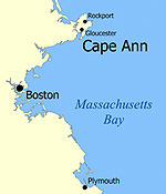
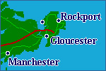
Where is Cape Ann? Answer: Cape Ann is located in Massachusetts on Boston's North Shore. The latitude/longitude for Rockport, which is on the tip of the island, is 42.6/70.6. Cape Ann consists of an island on which Rockport and half of Gloucester reside. The other half of Gloucester and the towns of Essex and Manchester-By-The-Sea on the mainland are also technically part of Cape Ann. When you approach from Route 128, you will see a sign as early as Beverly Farms proclaiming your arrival. See additional maps |
|
|
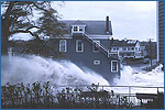
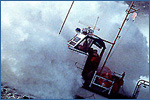
What is your experience with weather? Answer: That it can be nasty and fun at the same time as well as boring or powerful. I have had an intense interest in weather for over 35 years and with the introduction of the internet, I have been tracking weather daily for over 10 years. Once I had the training, I started building websites and that is how CapeAnnWeather.com was born. I believe the current version is the 6th or 7th. I have lived in Rockport here on the tip of Cape Ann all my life, have worked on a lobster boat in the winter. I have seen dozens of nor'easters over the years. I experienced the Blizzard of '78 like so many but can claim that I am the last person alive to have seen the captain, Frank Quirk, of the ill-fated pilot boat 'Can Do' before it perished on a rescue mission at the height of the storm. I took over 300 pictures of the Perfect Storm (right), several of which are of the USCG 44317, the very same boat the 'Can Do' was trying to reach 12 years earlier. The best part of New England is that just when (if) you get tired of one season, along comes another. top of page |
|
|
How do I know what the specific Cape Ann forecast is? Answer: Read the National Weather Service (NWS) full forecast on the Weather Center page. That is the standard and what millions of our dollars rightfully pay for nationally. While this forecast gives you a good scenario, you should realize that this forecast only gets locally written at about 4am and 4pm daily with minor alterations in between. If there is impending weather such as NWS weather advisories, watches or warnings, you will find that information linked on the CapeAnnMass.com front page as the NWS releases them. top of page |
|
|
When is it going to start raining/snowing? Answer: The most up-to-date Dopplar technology can show where the rain line is within 2-3 minutes of it happening and within 1/8 mile accuracy, depending on the graphics. I use the NWS IInteractive Dopplar Loop, found on the Weather Center page in the right navigation bar. With this radar you can zoom, change speeds, modify tags and it's updated approximately every 6-7 minutes. You can also visit the Cape Ann Imagery page for additional radar links. top of page |
|
|
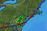
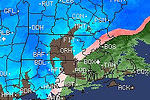
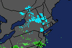
Which radar on the Imagery page is the most accurate? Answer: All New England radar images are from the same NWS radar facilities in Taunton, Massachusetts, Gray, Maine or Albany, New York. (With the exception of media feeds such as WBZ-TV4 and WCVB-5) The difference is the graphic package designed for the incoming data and how it is displayed on your browser. The NWS radars are set for either "clear air" or "precipitation" mode. When in the less sensitive "precipitation" mode, the first stage green color is precipitation (rain) but not typically reaching the ground. The Weather Underground radar we feature on our front page is much more sensitive and shows only absolute rainfall reaching the ground.
In the examples to the
right, blue is used for snow and pink for mixed precipitation. top of page |
|
|
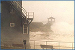
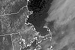
It
stopped raining, when will the sun come out? Answer: Visit the Weather Center and click on Visible Satellite Loop in the right navigation bar. This will show a loop of where the clouds are and their movement (right). If it is night time, click IR Satellite Loop for an infra-red view (but the sun likely won't come out until morning). Remember that the radar can not sense fog or very low cloud decks and while it may appear clear on the radar, it might not be clear where you are. top of page |
|
|
When is high tide at the North Shore beach I am going to? Answer: Go to the Weather Center and click on North Shore Tide Charts in the right navigation bar. Then click on the area on the map you want or the area and month in the text area. You can also find out Sun rise/set times and well as the Moon fazes. top of page |
|
|
Is the Boston forecast on the TV accurate for Cape Ann? Answer: Well, we don't want to ruffle feathers here but the truth is, at times, no. First of all, Boston media outlets reach a tremendous amount of people over a wide range of weather possibilities. They are generally vanilla for this reason. Cape Ann has historically been left out of the specifics on Boston media for the larger and more popular Cape Cod. I will say though that when they say "except the Cape and the Islands", a lot of times that can apply to Cape Ann also, but not always. The most obvious differences occur in the heat of the summer and in the winter. Water temperature dictates much of the Cape Ann weather anomalies such as snow fall, or lack of, in the winter and temperatures in the summer. In the summer the water is cooler than the air and in the winter it is usually warmer than the air. In the winter, while it can be accumulating snow in West Gloucester 2-3 miles just off island, it may very well be all rain on Cape Ann proper and stay that way. We have also been the victim of ocean effect snows of 6-10 inches while the sun has shone all day just 5 miles to the west. In the summer, the ocean waters reach about 68-70 degrees. If it is 96 inland and a SW wind is blowing, it may only reach 80-84 on the south facing beaches of Gloucester and Rockport! So the ocean water can be our friend or our foe. top of page |
|
|
Aren't a lot of weather people just guessing? Answer: Well, I don't think anyone whose job it is to predict the atmosphere is "guessing" but there seems to be a predictable attitude that to change what one initially observes or predicts is an admission of being wrong. The most reliable situation you can offer the public is to make them aware of more rapid than expected changing circumstances. A recent example is one of thunderstorms in Essex County in early July. It bothered me when the NWS suddenly posted numerous thunderstorm warnings without having ever posted a watch, which to me should be standard procedure. I am sure they had a reason but consistency is warranted here. I like the fact I see dozens of people popping onto Cape Ann Weather when the rumble of thunder is nearby and I am posting that info in real time for them. top of page |
|
|
Why don't you list marine warnings on your front page? Answer: First of all, I am quite sure that most people on a pleasure boat beached over at Wingaersheek Beach or Gloucester Harbor having a cocktail are not on their laptops. Second, I am sure that the commercial marine crowd has their own source of official weather, likely NOAA weather, that they rely on before they even leave the dock. In the reality of it, no one should be away from safe harbor further than necessary if they truly know the situation or possibility of that situation. NOAA weather radio, used by serious mariners, is probably the most accurate source there is. I do have a Boating & Marine page with resources on it but leave the extremes to the NWS. top of page |
|
|
How many people see or use your site? Answer: Well, let's just say that in the past 3 years I have had to upgrade my service hosting plan twice to accommodate the traffic bandwidth. Remember, Cape Ann Weather is not a global site selling something with no boundaries... it is a regional interest site for the Boston area. While the main CapeAnnMass.com site gets more of a wide slice because of its touristy nature, Cape Ann Weather peaks in times of, shall I say, inclemency. When inclement weather is imminent, traffic spikes. I can see this in real-time and while most are local, I am sure I attract people further away as a pure weather interest. I also see small spikes in traffic early in the morning and at lunch time... top of page |
|
|
Why don't you have your own weather station? Answer: I did have a WeatherMax for several years but the anemometer broke. I still have the rest of it though. Where I am located right now, while near the open water, it is sheltered and I would have to have it up a bit but that shouldn't effect the other readings, of course. For now, I link to the Sandy Bay Yacht Club device just 200 yards from me. That has been a good reliable source so until I can afford to replace mine, that will do quite well. top of page |
|