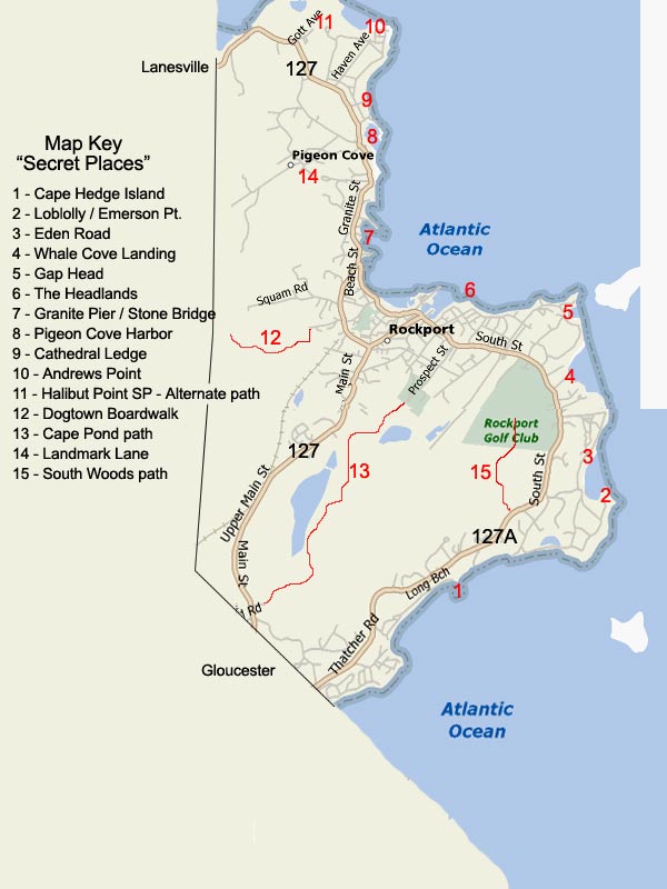
The following is a list of special places in Rockport we like
to say are "local" spots. Some are easy to access or find,
others are not so well known and there are others like the
trails of Dogtown that are a whole separate beast. For many of these spots, we recommend bug spray
and good
hiking footwear. Please respect all
RESIDENT ONLY parking signs
or you
WILL get a ticket. Alternative parking is often
nearby. Click on the map to the right
to reference the numbered items below. We also have an Interactive
Rockport Map that
you can use to zoom in to street level. OK?
Ready? Let's enjoy.... Shhhhh! It's a secret!!!
Cape Hedge Island (1) - While Cape Hedge is a well known
Rockport beach, the island between it and Long Beach is a miniature
treasure for exploring or snuggling with a special someone at sunset
and a bottle of red. Accessible from the parking lot at the end of Seaview St.
Loblolly Cove / Emerson Point (2) - Another secluded spot great
for surf fishing or a picnic in a rocky crag. A wonderful close view
of Twin Lights (Thacher Island) awaits those who walk a few minutes
over granite shards. Accessible from Old Penzance Road via Rt. 127A
at Turks Head Inn.
Eden Road / Flat Ledges (3) - Eden Road is one of those roads
where the residents prefer it to be a wreck so no one drives
through. Access it from South St. or via Penzance Road off Rt. 127A. Close
views of Thacher Island's Twin Lights and raucous waves in a nor'easter right
next to you. There is also a "Way To" path to the rocks.
Whale Cove Landing (4) - A plaque for Samuel D. Champlain on a
chicane of South St. marks the entrance to this gem.
Private Road!
You must park on South St. and access by foot past the horse farm or you
will get towed or fined. At the end,
walk to the right along the cliff gently down to the landing or
delve right down steeply towards the water through a natural path/brook bed.
Gap Head (5) - While Marmion Way is one of those popular trails
a local takes to scope out a nor'easter wave or two, Gap Head is
meant to be viewed in all climes. It's proximity to Straitsmouth
Island is never more appreciated. Architectural evidence of the old Rockport
Life Boat station exists on the north shore of the cove.
The Headlands (6) - The overlook capital of Cape Ann. A
wonderful bench laden dome of granite and grassy picnic patches with
views of the village steeples and the elevated perspective of sails
on Sandy Bay, the breakwater, Dry Salvages and Straitsmouth
Lighthouse. Accessible off South St. via Norwood Ave. to Atlantic
Ave.
Pigeon Cove Harbor (8) - Further along Granite Street, one comes
to an opening with a quick glimpse of the water just after the Cove
chapel. Taking a right after the old Cape Ann Tool Company, find
your way down to the Pigeon Cove Coop Fish Market. The shacks and working
fleet offer a wonderful serene element of closeness that downtown Rockport
does not.
Granite Pier / Old Stone Bridge (7) - Along Granite Street one
crosses over a keystone granite bridge into "God's Country", AKA Pigeon
Cove. Immediately after the crossing, bang a right. You will be splashed
with an elevated view of Sandy Bay. Descend to the base and curl to
the right. A short walk from the dry docked fleet is the under belly
of the old bridge and the adventurous ones will continue on up to
various quarries.
Cathedral Ledges (9) - Just up the shore dirt road from Pigeon
Cove Harbor is Cathedral Ledges. Also accessible from Cathedral Ave.
next to the Ralph Waldo Emerson Inn, this is a popular diving spot
and lazy afternoon picnic locale.
Andrews Point (10) - Well down off Granite St. on Phillips Ave.,
past mansions and wooded lots, is Point De Chene Ave. which opens up
to the Atlantic at Andrews Point. A public "Way To" allows for
picnics on the rocks with views of Thachers Island and Sandy Bay to
the south and the New Hampshire and Maine coast to the north.
Halibut Point State Park - Alternate trail (11) - Halibut
Point State Park off Route 127 has been a wonderful utilization of
public land gone federal for Rockport. It's self- guided tour of the
quarry and granite industry alone is worth the hike. However, when
exiting the parking lot, go further along Gott Ave. and NOT into the
main entrance of the park. Following instincts, one comes to an
alternate path that skirts private land. This path with its canopy
of thickets and gentle slope to the water opens up into a grand view
of Ipswich Bay and the NH/Maine coasts. This is a great adventure in a
snowstorm or nor'east gale as the winds howl just above your head.
Dogtown Boardwalk (12) - A while back someone decided that the
access to a wooded swamp would be a great idea. What a thought. This
gem is in the thickets of Dogtown's edge, not far from Whales Jaw. Best access is from
the parking lot at the top of Summit Ave. Follow the road to the water tower and
then a path on its south side. This old fire trail is marked by spray painted
dots on the trees when it gets grown in and narrow. When you come to the concrete damn, look carefully for
the boardwalk on your right.
Cape Pond path (13) - Cape Pond is the main water supply for
Rockport. Accessible from Beech Grove Cemetery, this path is a bit
long and arduous and is tremendously buggy in summer months. You
pass Kelly's pond first then follow a well marked fire road to the
Pond.
Landmark Lane (14) - Drive up Landmark Lane from Granite Street
across from the Yankee Clipper Inn on Rt. 127. The water tower on
top marks its summit. While growth has all but stifled what once
were wonderful views of the coast to the north, the fields on the
south are wonderful picnic area's overlooking the village.
South Woods (15) - This is a rather short woods hike from
the base of the 4th tee of the Rockport Golf Club (Off Rt. 127A) to the South End
water tower. It can be buggy in the summer and can be very muddy
even after a light rainfall. Down the road from the tower is the continuance of
127A.