·
Welcome to the Resources page of Cape Ann Weather (CAW) on Facebook. Here
you will find information that may help you follow forecasts and posts on CAW. You
have likely been redirected here after asking a question or seeking an explanation
relative to something I posted. Please feel free to send me an email at
cspittle@gmail.com if you do not see what you came here for.
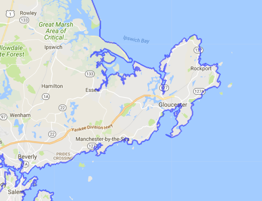
· Cape Ann Weather (Twitter, Facebook or .com) covers Eastern Essex County (NWS Zone 007) and the North Shore
area of Boston, Massachusetts from Revere to Salisbury, Rowley to Rockport.
(See coverage map
here)
CAW is not partnered or associated with the National Weather Service (NWS), NOAA, FEMA, TPC or any other government, official or media weather reporting and/or forecasting service.
See long form of CAW disclaimer and Legal Policy
here.
· Please visit my website:
CapeAnnWeather.com, for a plethora
of links and weather resources for the area. Specific pages include a
"Weather Center", the
"Tropics" (Hurricanes), "Marine" interests and the "CAW Web Cam Network", as well as an
extensive "Links and Imagery" page to radars, models and other pages.
· If you use Twitter, the handle is
@capeannweather.
· POSTED PHOTO'S - When I post new or unique photo's of weather phenomena,
nature, space or other related images that are related within the theme
or charter of the page, they usually come from Twitter or Facebook. If
so, and they are not mine and are accompanied by owner/source
information, I always credit in kind. When the info is absent or if the
image is a known historical stock image that has been around for a
while, there is no credit. Weather graphics from the NWS and other
weather source foundries are general public domain and not subject to
copyright boundaries although I usually credit media sources on
graphics.
DAILY FORECAST
*
Every morning on the CAW for FB page, a current Gloucester, MA observation, almanac and forecast for Cape Ann
is posted, usually by 700a. Here is a sample and explanations, where
necessary:
· Clear. 30° (BVY: 19°); Winds: SW10.
(Sky, local temp, Bevery Airport temp and wind
direction and speed)
· DP: 26°; BP: 30.26S; RH: 81%.
(Dew Point, Barometric Pressure and Relative
Humidity)
· Normal T° FTD (BOS): Hi35.4° / Lo21.8°.
(Normal High and Low temp for the date in Boston)
· Sunrise: 706a / Sunset: 446p.
· Sea Temp: 41.4° (Buoy #44029) / High Tide: 953a/1034p.
(Ocean water temp at closest buoy)
· On-Island Today: Sunny. Cold. Breezy. Hi45°. Winds: SW8.
· Tonight: Cloudy. Lo29°. Winds: Becoming N6.
· Tomorrow: Partly sunny. Hi44°. Winds: SW10.
· GLOSSARY
*
This is the glossary of accronyms, terms and abbreviations that I
may occasionally use in reports,
forecasts and other posts. Please feel free to message me with any terms
not listed here.
NWS - National Weather Service.
· PLACES:
RHS - Rockport High School’s weather station. Used for the fact it’s
new, calibrated and in the center of the island, not on the coast.
PB - Pebble Beach, a Weather Station run by Rockporter Ken Baker, used because it
IS on the coast (And he has a cool webcam).
CC - Cape Cod or “The Other Cape”.
The Rockpile – Mt. Washington.
MWObs: Mt. Washington Observatory.
BVY - Beverly Airport, the closest NWS official weather observation
location to Cape Ann.
BOS - Logan International Airport, where most local records since 1872
originate.
BHO - Blue Hill Observatory in Milton, MA. Founded in 1885.
BM - BenchMark, (see "40N/70W" below)
· WEATHER TERMS:
AFD -
Area Forecast Discussion (NWS Product).
CAPE: Convective Available Potential Energy
Clipper -
An Alberta "Clipper" is a fast moving storm system during the winter months that originates from the Canadian provinces of Alberta, Saskatchewan
or Manitoba). The term "Clipper" originates from the clipper sailing ships because of their quick speeds.
CPC -
Climate Prediction Center
CWA - County Warning Area (NWS Zone 007 Eastern Essex County)
DP - Dew Points
FROPA - Frontal Passage
HWO - Hazardous Weather Outlook
ISS - International Space Station
MSLP - Mean Sea Level Pressure
NHC -
National Hurricane Center
OBS (Obs) - A weather-related OBServation
OE - Ocean Effect
PWS - Personal Weather Station
SPC -
Storms Prediction Center
SST - Sea Surface Water Temperature. (See map below)
TD - Tropical Depression
TS - Tropical Storm
Tz - Thunderstorm(s)
Virga - Rain/light snow which falls from the clouds but dries up and does not reach
the ground.
WIND:
NW10/G22 = Northwest at 10MPH, Gusts to
22MPH.
WC (or WCI) - Wind Chill (Index) OBS or forecast
(See chart below).
WPC -
Weather Prediction Center
·
TIMESTAMP: 0Z/12Z - Many models and some maps/radars are time-stamped
solely with 24-hour 'Z' or 'Zulu' time (Greenwich Mean Time, in the UK).
Models are usually run every 12 hours, at 0Z or 12Z. Radars and
satellite images are stamped at time of creation. In the Winter, deduct
5 hours for Eastern/local time. Deduct 4 hours in Summer for Daylight Savings
Time (DST).
Examples: 12Z (minus 5 hours) = 7AM local and 17Z (minus 5 hours) = 1200p
(noon).
·
MODELS: GFS: Global Forecast System; GEFS: GFS Ensemble; EURO (ECMWF): European derived model
system; NAM: North American Model;
·
MODEL TERMS: Members/ensembles: A group of model inputs to the same
formula to create the mean result;
Run: When models are prompted to produce a result. Usually at 0Z or 12Z,
some are run at 6-hour intervals as well.
·
40N/70W
Benchmark (See Map below) - When nor'easters travel NE or NNE over or very near the
intersection of 40N latitude and 70W longitude due south of Nantucket MA,
they usually are rain/snow storms that impact the "I-95 Corridor" in the Boston/Providence/Portland metropolitan
areas. This covers anywhere from the Cape Cod Canal to the coastal plain of the Cape Ann/North Shore area
up thru coastal NH. Any storm that tracks significantly further West of this
spot, then rain is likely for those area's. A track further East of this
benchmark and all effects
will be diminished unless the system is abnormally large, such as the
most recent March 13, 2018 blizzard.
·
NWS
HEADLINES - When the NWS service issues Watches,
Advisories or Warnings
for the level of impact by a particular event. Multiple Headlines are
common. (NOTE: A 'Blizzard' Watch or Warning includes Wind Headlines).
·
NWS HEADLINE DESCRIPTION - (Watch, Advisory, Warning):
In short,
· A "Watch" is to make the public AWARE of a possible issue.
· An "Advisory" is for the public to EXPECT that issue.
· A "Warning" is stating that the issue is IMMINENT, sometimes on very short notice,
like for a Tz or tornado.
· Many times a "Hazardous Weather Outlook" has been posted over 24 hours
ahead of time.
·
Headlines usually apply to, but are not limited to, expected weather such as
snow, freezing rain, wind, wind chill, freeze, coastal flooding, tropical
storms, heat, thunderstorms and tornadoes.
The Definitions:
·
A Watch is issued when there is the potential for
significant and hazardous weather within 48 hours. It does not
mean that significant and hazardous weather will occur...it only
means it is possible.
·
A Weather Advisory will be issued for any amount of weather that is expected to cause a significant inconvenience,
but not serious enough to warrant a warning.
·
A Warning is issued when a significant combination of
hazardous weather is occurring or imminent.
Top of Page
IMAGE RESOURCES - (Click to enlarge an image into new window).